Showing posts with label Canada. Show all posts

Saturday, 1 March 2014


Yukon Territory, Canada:


Yukon is the westernmost and smallest of Canada's three federal territories. Whitehorse is the territorial capital.The territory was split from the Northwest Territories in 1898. Receiving royal assent on March 27, 2002, the federal government modernized the Yukon Act to confirm "Yukon", rather than "Yukon Territory", as the current usage standard.Though officially bilingual, the Yukon Government also recognizes First Nations languages.At 5,959 m, Yukon's Mount Logan, in Kluane National Park and Reserve, is the highest mountain in Canada and the second-highest on the North American continent. The territory's climate is Arctic in the north, subarctic in the central region, between north of Whitehorse and Old Crow, and has a humid continental climate in the far south, south of Whitehorse and in areas close to the British Columbia border. Several rivers run through Yukon, some being the Stewart River, Peel River, and ever famous Yukon River.


Source:
Picture:Link:
Wikipedeia:Link:
Read More 0 comments

Friday, 28 February 2014


St. John's, Newfoundland, Canada:


St. John's is the capital and largest city in Newfoundland and Labrador. St John's was incorporated as a city in 1921, yet is considered by some to be the oldest English-founded city in North America.It is located on the eastern tip of the Avalon Peninsula on the island of Newfoundland.With apopulation of 200,600 as of 2012, the St. John's Metropolitan Area is the second largest Census Metropolitan Area in Atlantic Canada after Halifax and the 20th largest metropolitan area in Canada.Its name has been attributed to the feast day of John the Baptist, when John Cabot was believed to have sailed into the harbour in 1497, and also to a Basque fishing town with the same name.Newfoundland was claimed as an English colony in the name of Elizabeth I in 1583, temporarily captured by the Dutch in 1665, and attacked three times by the French who captured and destroyed its settlements in 1689 and 1707. St John's was retaken each time and re-fortified. British forces used St. John's fortifications during the Seven Years' War in North America, the American Revolutionary War and the War of 1812. St. John's served Allied needs in World War II by providing an air base for the USAAF and a harbour for antisubmarine warfare ships.St. John's, and the province as a whole, was gravely affected in the 1990s by the collapse of the Northern cod fishery, which had been the driving force of the provincial economy for hundreds of years.After a decade of high unemployment rates and depopulation, the city's proximity to the Hibernia, Terra Nova and White Rose oil fields has led to an economic boom that has spurred population growth and commercial development. As a result, the St. John's area now accounts for about half of the province's economic output.

Source:
Picture:Link:
Wikipedeia:Link:
Read More 0 comments

Monday, 17 February 2014


Moraine Lake Banff National Park, Alberta, Canada:


Moraine Lake is a glacially-fed lake in Banff National Park, 14 kilometres outside the Village of Lake Louise, Alberta, Canada. It is situated in the Valley of the Ten Peaks, at an elevation of approximately 6,183 feet. The lake has a surface area of .5 square kilometres.The lake, being glacially fed, does not reach its crest until mid to late June. When it is full, it reflects a distinct shade of blue. The colour is due to the refraction of light off the rock flour deposited in the lake on a continual basis.


Source:
Picture:Link:
Wikipedeia:Link:
Read More 0 comments

Sunday, 2 February 2014


Nimmo Bay, British Columbia:


British Columbia  is a province located on the West Coast of Canada. British Columbia is also a component of the Pacific Northwest, along with the U.S. states of Oregon and Washington.The province's name was chosen by Queen Victoria in 1858, reflecting its origins as the British remainder of the Columbia District of the Hudson's Bay Company. In 1871, it became the sixth province of Canada. Its Latin motto is Splendor sine occasu.The capital of British Columbia is Victoria, the 15th largest metropolitan region in Canada, named for the Queen that created the Colony of British Columbia. The largest city is Vancouver, the third-largest metropolitan area in Canada, the largest in Western Canada, and the second largest in the Pacific Northwest. In 2012, British Columbia had an estimated population of 4,622,573. The province is currently governed by the BC Liberal Party, led by Premier Christy Clark, who became leader as a result of the party election on February 26, 2011 and who led her party to an election victory on May 14, 2013.British Columbia's economy is largely resource-based. It is the endpoint of transcontinental railways and the site of major Pacific ports, which enable international trade. Though less than five percent of its vast 944,735 km2 land is arable, the province is agriculturally rich because of its mild weather. Its climate encourages outdoor recreation and tourism, though its economic mainstay has long been resource extraction, principally logging, farming, and mining. Vancouver, the province's largest city and metropolitan area, also serves as the headquarters of many of the Western-based natural resource companies. It also benefits from a strong housing market and a per-capita income well above the national average. While the coast of BC and certain valleys in the south-central part of the province have mild weather, the majority of BC's land mass experiences a cold winter temperate climate similar to the rest of Canada. The Northeast corner of BC has a Subarctic climate with very cold winters.


Source:
Picture:Link:
Wikipedeia:Link:
Read More 0 comments


Screaming Heads, Ontario, Canada:


Ontario Listeni/ɒnˈtɛərioʊ/ is one of the ten provinces of Canada, located in east-central Canada.It is Canada's most populous province by a large margin, accounting for nearly 40% of all Canadians, and is the second largest province in total area. Ontario is fourth largest in total area when the territories of the Northwest Territories and Nunavut are included.It is home to the nation's capital city, Ottawa, and the nation's most populous city, Toronto.Ontario is bordered by the province of Manitoba to the west, Hudson Bay and James Bay to the north, and Quebec to the east, and to the south by the U.S. states of Minnesota, Michigan, New York, Ohio and Pennsylvania. All but a small part of Ontario's 2,700 km border with the United States follows inland waterways: from the west at Lake of the Woods, eastward along the major rivers and lakes of the Great Lakes/Saint Lawrence River drainage system. These are the Rainy River, the Pigeon River, Lake Superior, the St. Marys River, Lake Huron, the St. Clair River, Lake St. Clair, the Detroit River, Lake Erie, the Niagara River, Lake Ontario and along the St. Lawrence River from Kingston, Ontario, to the Quebec boundary just east of Cornwall, Ontario.Ontario is sometimes conceptually divided into two regions, Northern Ontario and Southern Ontario. The great majority of Ontario's population and its arable land is located in the south. In contrast, the larger, northern part of Ontario is sparsely populated.

Source:
Picture:Link:
Wikipedeia:Link:
Read More 0 comments

Sunday, 26 January 2014


Summer, Waterton, Canada:


Waterton Lakes National Park is a national park located in the southwest corner of Alberta, Canada, and borders Glacier National Park in Montana, USA. Waterton was Canada's fourth national park, formed in 1895 and named after Waterton Lake, in turn after the Victorian naturalist and conservationist Charles Waterton. The park contains 505 km2 of rugged mountains and wilderness.Operated by Parks Canada, Waterton is open all year, but the main tourist season is during July and August. The only commercial facilities available within the park are located at the Waterton Park townsite. The park ranges in elevation from 1,290 metres at the townsite to 2,910 m at Mount Blakiston. It offers many scenic trails, including Crypt Lake trail. In 2011/2012, Waterton Lakes National Park had 400,520 visitors.The park was the subject of a short film in 2011's National Parks Project, directed by Peter Lynch and scored by Cadence Weapon, Laura Barrett and Mark Hamilton.American TV talkshow host David Letterman recommended the park on the Monday, 24 June 2013 episode of his nightly show. In an interview with Melissa McCarthy he told her, “when you go to Montana, you gotta' go North to Glacier ... and then dip-up into Waterton International Peace Park, it’s the Canadian part of Glacier National Park. It’s stunning.” The quotation was covered by several Canadian news outlets.

Source:
Picture:Link:
Wikipedeia:Link:
Read More 0 comments

Saturday, 18 January 2014


Frozen Montmorency Falls, Quebec, Canada:


The Montmorency Falls is a large waterfall on the Montmorency River in Quebec, Canada.The falls are located on the boundary between the borough of Beauport, Quebec City, and Boischatel, about 12 km from the heart of old Quebec City. The area surrounding the falls is protected within the Montmorency Falls Park.The falls, at 84 meters high and 46 meters wide, are the highest in the province of Quebec and 30 meters higher than Niagara Falls. The basin at the foot of the falls is 17 meters deep. The falls are at the mouth of the Montmorency River where it drops over the cliff shore into the Saint Lawrence River, opposite the western end of the Île d'Orleans. The falls were given this name in 1613 by Samuel de Champlain. He named them in honour of Henri II, duc de Montmorency, who served as viceroy of New France from 1620 until 1625.There are staircases that allow visitors to view the falls from several different perspectives. A suspension bridge over the crest of the falls provides access to both sides of the park as well as a spectacular view. There is also an aerial tram that carries passengers between the base and the top of the falls. In the summer the park hosts an international fireworks competition with the falls as a backdrop.The remnants of earthen forts built by General Wolfe are located in the eastern portion of the park. They were constructed in 1759. The landings below Quebec City were repulsed by General Montcalm at Montmorency Falls, costing the British 440 soldiers. Ultimately a successful assault was launched when Wolfe made a surprise attack by climbing the cliffs below the Plains of Abraham.The Falls were the site of a key scene between the lead actors in the 1947 film Whispering City, which was filmed on location.The Ice Hotel was located at Montmorency Falls for its first year.In his poem "Sleep and Poetry" , John Keats says that human life is "a poor Indian's sleep / While his boat hastens to the monstrous steep / Of Montmorenci."

Source:
Picture:Link:
Wikipedeia:Link:
Read More 0 comments

Friday, 17 January 2014


Maligne Lake, Jasper National Park, Alberta, Canada:


Maligne Lake is a lake in Jasper National Park, Alberta, Canada. It is famed for the colour of its water, the surrounding peaks, the three glaciers visible from the lake and Spirit Island, one of the most photographed locations in the world. The lake is located 44 km south of Jasper town, and is accessible by motor vehicle, including shuttle buses from Jasper. Boat tours run to Spirit Island in the spring to autumn season. The 44 km Skyline Trail, Jasper's most popular, highest and above treeline, multi-day hike, begins at Maligne Lake and finishes near the town of Jasper. Other popular day hikes include the Opal Hills and Bald Hills loops. Winter activities include cross-country skiing.Maligne Lake is approximately 22.5 km long and is 97 m at its deepest point, in the south end of the lake. It averages 35 m in depth. It sits at approximately 1,670 m asl. Easily visible from the Maligne Lake Day Lodge are Leah and Samson Peaks and Mount Paul to the east, and Mounts Charlton, Unwin, Mary Vaux and Llysfran Peak to the south and west. The Charlton, Unwin and Maligne glaciers are visible from the lake, which boasts a self-sustaining population of introduced rainbow trout and brook trout. It is a popular spot for sport fishing, kayaking and canoeing. Parks Canada maintains two camping sites, accessible only by canoe, at Fisherman's Bay and Coronet Creek.Maligne Lake is fed and drained by the Maligne River, which enters the lake on its south side, near Mount Unwin and drains the lake to the north. Maligne Lake, as well as Maligne River, Maligne Mountain, and Maligne Pass, takes its name from the French word for malignant or wicked. The name was used by Father Pierre-Jean De Smet to describe the turbulent river that flows from the lake, and soon spread to the lake, canyon, pass, mountain and range. It is also possible that early French traders applied the name to the river for its treacherous confluence with the Athabasca River.The lake was well known to First Nations of the area, including Samson Beaver, who knew it as Chaba Imne. He drew the first map of the lake and the route to it for Mary Schaffer in 1907.Schaffer was a surveyor who explored much of the Rocky Mountains area. The first European to actually see the lake was Henry McLeod, scouting routes for the CPR in 1875. When he sighted it, he was high in the mountain range and did not actually go into the lake area or identify the route to the lake. June 8, 1908, with the help of Samson Beaver's map, Schaffer, her travelling companion Mary Adams and the guides Billy Warren and Sid Unwin, set out from Lake Louise to reach the lake known by the Stoney people as Chaba Imne. When they arrived at the lake, they explored it with the means of a raft, nicknamed the HMS Chaba. Schaffer returned in 1911 to survey the lake. She also named several of the mountains and peaks. Mary Schaeffer's books of the area attracted tourists from all over the US.Maligne Lake is the location of two Alberta registered historic buildings, the Maligne Lake Chalet and accompanying guest house, washhouse, and cache, all built in 1927 by Col. Fred Brewster as a part of his "Rocky Mountain Camps". For a time, the Maligne Lake Chalet was the largest, most luxurious accommodation in Jasper National Park. The other historic building is the Boathouse, built by Donald 'Curly' Philips in 1928 to accommodate his wilderness guiding and fishing business. In the same year, he finished construction of the first Maligne Lake Tour boat, the Leah. Philips resided in his boathouse until his untimely death in an avalanche. The historic buildings are maintained by Maligne Lake Tours, a company that dates back to Brewster's and Philips' early entrepreneurial endeavours.Curly Philips is credited with stocking Maligne Lake with rainbow trout, packed overland in barrels. The largest rainbow trout in Alberta was subsequently caught in this lake by means of sportfishing. The record fish was mounted and is currently owned by Currie's Guiding and Tackle, Jasper, Alberta, Canada.Jasper National Park staff later introduced brook trout. The third largest brook trout in the world was also sportfished from this lake and is owned by David Robson of Hinton, Alberta, Canada.


Source:
Picture:Link:
Wikipedeia:Link:
Read More 0 comments

Thursday, 16 January 2014

Banff National Park, Canada:


Banff National Park /ˈbæmf/ is Canada's oldest national park, established in 1885 in the Rocky Mountains. The park, located 110–180 km west of Calgary in the province of Alberta, encompasses 6,641 km2 of mountainous terrain, with numerous glaciers and ice fields, dense coniferous forest, and alpine landscapes. The Icefields Parkway extends from Lake Louise, connecting to Jasper National Park in the north. Provincial forests and Yoho National Park are neighbours to the west, while Kootenay National Park is located to the south and Kananaskis Country to the southeast. The main commercial centre of the park is the town of Banff, in the Bow River valley.The Canadian Pacific Railway was instrumental in Banff's early years, building the Banff Springs Hotel and Chateau Lake Louise, and attracting tourists through extensive advertising. In the early 20th century, roads were built in Banff, at times by war internees, and through Great Depression-era public works projects. Since the 1960s, park accommodations have been open all year, with annual tourism visits to Banff increasing to over 5 million in the 1990s.Millions more pass through the park on the Trans-Canada Highway.As Banff is one of the world's most visited national parks,the health of its ecosystem has been threatened. In the mid-1990s, Parks Canada responded by initiating a two-year study, which resulted in management recommendations, and new policies that aim to preserve ecological integrity.Throughout its history, Banff National Park has been shaped by tension between conservation and development interests. The park was established in 1885, in response to conflicting claims over who discovered hot springs there, and who had the right to develop the hot springs for commercial interests. Instead, Prime Minister John A. Macdonald set aside the hot springs as a small, protected reserve, which was later expanded to include Lake Louise and other areas extending north to the Columbia Icefield.

Source:
Picture:Link:
Wikipedeia:Link:
Read More 0 comments

Monday, 23 December 2013

Mount Edith Cavell,Jasper National Park, Canada:


Mount Edith Cavell is a mountain located in the Athabasca River and Astoria River valleys of Jasper National Park, Canada. The mountain was named in 1916 for Edith Cavell, an English nurse and executed by the Germans during World War I for having helped allied soldiers escape from occupied Belgium to the Netherlands, in violation of military law.It was previously known as la montagne de la Grande traversée because it stands above Athabasca Pass.A close up view of the north face of Mt. Edith Cavell is visible after a short hike to Cavell Meadows. The trailhead is by the parking lot at the end of Mt. Edith Cavell road. The trail to the meadows is 3.8 kilometres one way, rising 370 metres to 2,135 metres. The Canadian Rockies Trail Guide describes the trail in detail.The hanging Angel Glacier is visible from Cavell Meadows, which spills over a 300 metres cliff on the north face.Access to the Tonquin Valley trails can be found about one km before the end of the Mt. Edith Cavell road. There is a parking area across from the Mt. Edith Cavell Hostel. A short walk down the gravel path leads to the north end of Cavell Lake. There is small bridge across the stream that empties the lake. From here there are good views with the lake in the foreground and the Mt. Edith Cavell massif in the background.It is believed that the world's largest glacial erratic located in Okotoks, Alberta, was once part of Mt. Edith Cavell. The erratic was formed approximately ten thousand years ago when a large portion of quartzite stone was stripped away from the mountain along with the receding Athabasca River Valley glacier.\

Source:
Picture:Link:
Wikipedeia:Link:
Read More 0 comments

Wednesday, 11 December 2013


Lake Bennett, Canada:


Bennett Lake is a lake that sits partly in the Province of British Columbia and partly in Yukon, both located in northwestern Canada. It is just north of the border with the United States state of Alaska, near the Alaskan port of Skagway.The narrow-gauge White Pass and Yukon Route Railroad connects Bennett, British Columbia at the south end of the lake with Skagway further south and Whitehorse, Yukon on the north. It runs between Skagway and Fraser, British Columbia during the summer months.The abandoned town of Bennett, British Columbia, historically usually referred to as Lake Bennett or Bennett Lake and the town of Carcross, Yukon are on the shores of Bennett Lake.During the Klondike Gold Rush, Bennett Lake was where the gold-seekers who had crossed the Coast Mountains from Skagway or Dyea, carrying their goods over the Chilkoot Trail or the White Pass, purchased or built rafts to float down the Yukon River to the gold fields at Dawson City, Yukon, Canada. A large tent city sprang up on its shores, numbering in the thousands and offering all the services of a major city. In late May 1898, the North-West Mounted Police counted 778 boats under construction at Lindeman Lake, 850 in Bennett and the surrounding area, and another 198 at Caribou Crossing and Tagish Lake to help transport thousands of goldfield-bound travellers. It was further estimated that another 1,200 boats were built in these areas over the next few weeks.

Source:
Picture:Link:
Wikipedeia:Link:
Read More 0 comments

Thursday, 21 November 2013


Jasper National Park,Canada:


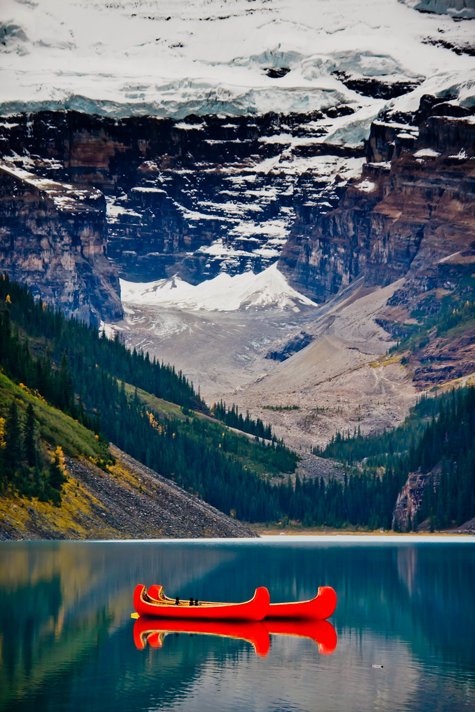
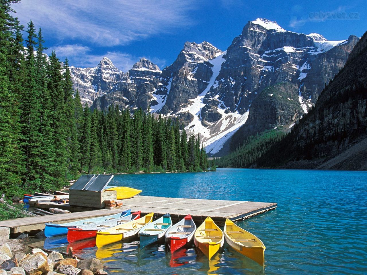
Jasper National Park is the largest national park in the Canadian Rockies, spanning 10,878 km2. It is located in the province of Alberta, north of Banff National Park and west of the City of Edmonton. The park includes the glaciers of the Columbia Icefield, hot springs, lakes, waterfalls and mountains. Wildlife in the park includes elk, caribou, moose, mule deer, white-tailed deer, mountain goats, bighorn sheep, grizzly bears, black bears, coyotes, beavers, Rocky Mountain pikas, hoary marmots, grey wolves, mountain lions, and wolverines.Jasper was named after Jasper Hawes, who operated a trading post in the region for the North West Company. Before this it was referred to as Fitzhugh. The park was established on September 14, 1907 as Jasper Forest Park, and was granted national park status in 1930, with the passing of the National Parks Act.In 2011/2012, Jasper National Park had 1,958,206 visitors.This park was declared a UNESCO World Heritage Site in 1984, together with the other national and provincial parks that form the Canadian Rocky Mountain Parks, for the mountain landscapes containing mountain peaks, glaciers, lakes, waterfalls, canyons, and limestone caves as well as fossils found here.Major river systems originating in the park include the North Saskatchewan River, and the Athabasca and Smoky rivers.Some of the park's scenic attractions include Mount Edith Cavell, Pyramid Lake with Pyramid Mountain, Maligne Lake, Medicine Lake, and the Tonquin Valley. Other attractions are the Marmot Basin ski area; the Snocoach tours of the Athabasca Glacier, an outlet glacier of the Columbia Icefield; Athabasca Falls; the Jasper Tramway, and numerous other outdoor related recreational activities. The Miette Hot Springs are located close to the northeast entrance. The Miette Hot Springs are created by an extremely hot spring cooled by the mountain to temperatures suitable for humans.The Icefields Parkway is a highway 230 km in length from Lake Louise, Alberta in Banff National Park, to Jasper, Alberta. The highway parallels the continental divide, providing motor and cycle access to the mountains. The Athabasca and Sunwapta Falls are both accessible by the road.

Source:
Picture:Link:
Wikipedeia:Link:
Read More 0 comments

Tuesday, 19 November 2013


Moraine Lake, Alberta,Canada:


Moraine Lake is a glacially-fed lake in Banff National Park, 14 kilometres outside the Village of Lake Louise, Alberta, Canada. It is situated in the Valley of the Ten Peaks, at an elevation of approximately 6,183 feet. The lake has a surface area of .5 square kilometres.The lake, being glacially fed, does not reach its crest until mid to late June. When it is full, it reflects a distinct shade of blue. The colour is due to the refraction of light off the rock flour deposited in the lake on a continual basis.The area around the lake has several walking/hiking trails which are, from time to time, restricted. This is the one most commonly taken by tourists. The Rockpile Trail along the actual moraine is approximately 300 metres long, with an elevation change of 24 metres. The view of the lake from the top of the rockpile is one of the most photographed locations in all of Canada.That view of the mountains behind the lake in Valley of the Ten Peaks is known as the Twenty Dollar View, as Moraine Lake was featured on the reverse side of the 1969 and 1979 issues of the Canadian twenty dollar bill.Along the same trailhead, the Consolation Lakes trail starts, which is approximately 3 kilometres long, with an elevation change of 90 metres. Upon reaching Consolation Lakes hikers may continue along to the upper lake, which is not visible from the end of the lower lake. There is, however, no clearly marked trail, and can often be a scramble over large rocky areas.Near the canoe docks of Moraine Lake Lodge there is another trailhead. This trailhead is the start of two trails, one of which branches out into four different trails - so there are in total, five trails starting at that trailhead. The Lake Louise & Yoho Map provides information on these trails.

Source:
Picture:Link:
Wikipedeia:Link:
Read More 0 comments

Sunday, 10 November 2013


Capilano Suspension Bridge, Columbia:


The Capilano Suspension Bridge is a simple suspension bridge crossing the Capilano River in the District of North Vancouver, British Columbia, Canada. The current bridge is 140 metres long and 70 metres above the river. It is part of a private facility, with an admission fee, and draws over 800,000 visitors a year.The bridge was originally built in 1889 by George Grant Mackay, a Scottish civil engineer and park commissioner for Vancouver. It was originally made of hemp ropes with a deck of cedar planks, and was replaced with a wire cable bridge in 1903. In 1910 Edward Mahon purchased the Capilano Suspension Bridge. "Mac" MacEachran purchased the Bridge from Mahon in 1935 and invited local natives to place their totem poles in the park, adding a native theme. In 1945, he sold the bridge to Henri Aubeneau.The bridge was completely rebuilt in 1956.The park was sold to Nancy Stibbard, the current owner, in 1983. Annual attendance has since increased, and in May 2004, Treetops Adventures was opened. This new attraction consists of seven footbridges suspended between old-growth Douglas Fir trees on the west side of the canyon, forming a walkway up to 30 metres above the forest floor.As well as the bridge itself and Treetops Adventure, the first venue of its kind in North America, the park also features rain forest ecotours, award-winning gardens, nature trails, North America's largest private collection of First Nations totem poles, period decor and costumes, and exhibits highlighting the park's history and the surrounding temperate rain forest. Guests can also witness a First Nations performance, featuring their traditional Regalia, masks, dancing and storytelling. In June 2011, a new attraction called Cliff Walk was added to the park. This adventures is free and comes as a bundle along with the other attractions.In 1999, a woman dropped her 18-month-old, disabled child off the bridge. She claimed she stumbled accidentally and the child slipped from her grasp. The child was not seriously injured. The woman lost legal custody of her child as a result of the incident. The woman took legal action against the owner of the bridge, alleging negligence by the owner. The case was settled out of court.In 2006, a 300-year-old, 46-tonne Douglas fir tree toppled during a heavy snowstorm.The tree fell across the western end of the bridge. Park officials closed the bridge temporarily while repairs were performed.On June 6, 2010, a teenage tourist on a class trip from California climbed over a railing and fell more than 30 metres from a fenced off viewing platform near the bridge. By the time rescue workers came to his aid, the victim was dead.The official RCMP finding was that the teen was under the influence of LSD at the time of the incident.On June 2, 2012 a 30-year-old tourist from Ontario died after falling near the bridge. Police say the victim was hiking through trails near the popular attraction when he fell to the riverbed below.


Source:
Picture:Link:
Wikipedeia:Link:
Read More 0 comments

Wednesday, 6 November 2013

Lake Louise, Canada:


Lake Louise is a hamlet in Alberta, Canada within Improvement District.The hamlet is named for the nearby Lake Louise, which in turn was named after the Princess Louise Caroline Alberta, the fourth daughter of Queen Victoria, and the wife of John Campbell, the 9th Duke of Argyll, who was the Governor General of Canada from 1878 to 1883.The hamlet was originally called Laggan, and was a station along the Canadian Pacific Railway route. It was built in 1890.The train station building was preserved and moved into Heritage Park in Calgary.The hamlet is separated into two communities. The main community, referred to as The Village is at a lower elevation adjacent to the Trans-Canada Highway . It has a small shopping centre, Samson Mall, which includes a park visitor centre, grocery store, bakery, deli, grill, bar and sporting goods store. The ski area, Lake Louise Mountain Resort, is located across Highway 1. The second community is at a higher elevation and is centered around the Chateau Lake Louise, adjacent to Lake Louise.The community is also located on Alberta Highway 1A, and just south of the Icefields Parkway.As of 2001, Lake Louise had a total population of 1,041 living in 273 dwellings.Statistics Canada did not publish a population for Lake Louise from the 2006 census under its urban area or designated place programs. However, its 2006 population is approximately 777 based on data aggregated from the dissemination block level.The hamlet is located in census division No. 15 and in the federal riding of Wild Rose. It is administered by the Improvement District No.9 and is located beside the Trans-Canada Highway, 180 km west of Calgary. The background of Lake Louise is filled with views of several snow-capped mountains including Mount Temple , Mount Whyte and Mount Niblock.Lake Louise experiences a subarctic climate. Annual snowfall averages 3.3m and winter temperatures below −50°C have been recorded. Summers consist of frosty mornings and crisp, cool days. Snow can occur in any month of the year.

Source:
Picture:Link:
Wikipedeia:Link:
Read More 0 comments

Friday, 25 October 2013


Athabasca Falls, Canada:


Athabasca Falls is a waterfall in Jasper National Park on the upper Athabasca River, approximately 30 kilometres south of the townsite of Jasper, Alberta, Canada, and just west of the Icefields Parkway. A powerful, picturesque waterfall, Athabasca Falls is not known so much for the height of the falls, as it is known for its force due to the large quantity of water falling into the gorge. Even on a cold morning in the fall, when river levels tend to be at their lowest, copious amounts of water flow over the falls. The river 'falls' over a layer of hard quartzite and through the softer limestone below carving the short gorge and a number of potholes. The falls can be safely viewed and photographed from various viewing platforms and walking trails around the falls. Access is from the nearby parking lot, which leads off Highway 93A just northeast of the falls. Highway 93A takes off from the nearby Icefields Parkway, and crosses the falls on the way north to the town of Jasper. White water rafting often starts below the falls to travel downstream on the Athabasca River to Jasper.It is a Class 5 waterfall, with a drop of 80 ft and a width of 60 ft.


Source:
Picture:Link:
Wikipedeia:Link:
Read More 0 comments

Wednesday, 23 October 2013


Balancing Rock, Nova Scotia, Canada:


A balancing rock, also called balanced rock or precarious boulder, is a naturally occurring geological formation featuring a large rock or boulder, sometimes of substantial size, resting on other rocks, bedrock or on glacial till. Some formations known by this name only appear to be balancing but are in fact firmly connected to a base rock by a pedestal or stem. There is no single scientific definition of the term, and it has been applied to a variety of rock features that fall into one of four general categories.A glacial erratic is a boulder that was transported and deposited by glaciers to a resting place on soil, on bedrock or on other boulders. It usually has a different lithology than the other rocks around it. Not all glacial erractics are balancing rocks; some are firmly seated on the ground. Some balancing erractics have come to be known as rocking stones, also known as logan rocks, logan stones or logans, because they are so finely balanced that the application of just a small force may cause them to rock or sway. A good example of a rocking stone is the Logan Rock in Cornwall, England, United Kingdom; another is the Trembling Rock in Brittany, France.A perched block, also known as a perched boulder or perched rock, is a large, detached rock fragment that most commonly was transported and deposited by a glacier to a resting place on glacial till, often on the side of a hill or slope. Some perched blocks were not produced by glacial action but were the aftermath of a rock fall, landslide or avalanche.An erosional remnant is a persisting rock formation that remains after extensive wind, water and/or chemical erosion. To the untrained eye it may appear to be visually like a glacial erratic, but instead of being transported and deposited it was carved from the local bedrock. Many good examples of erosional remnants are seen in the Devils Marbles Conservation Reserve in the Northern Territory of Australia.A pedestal rock, also known as a rock pedestal or mushroom rock, is not a true balancing rock but is a single continuous rock form with a very small base leading up to a much larger crown. Some of these formations are called balancing rocks because of their appearance. The undercut base was attributed for many years to simple wind abrasion but is now believed to result from a combination of wind and enhanced chemical weathering at the base where moisture would be retained longest. Some pedestal rocks sitting on taller spire formations are known as hoodoos.

Source:
Picture:Link:
Wikipedeia:Link:
Read More 0 comments

Tuesday, 15 October 2013


Autumn leaf color is a phenomenon that affects the normally green leaves of many deciduous trees and shrubs by which they take on, during a few weeks in the autumn season, various shades of red, yellow, purple, and brown.The phenomenon is commonly called autumn colours or autumn foliage in British English and fall colors, fall foliage, or simply foliage in American English.In some areas of Canada and the United States, "leaf peeping" tourism is a major contribution to economic activity. This tourist activity occurs between the beginning of color changes and the onset of leaf fall.A green leaf is green because of the presence of a pigment known as chlorophyll, which is inside an organelle called a chloroplast. When they are abundant in the leaf's cells, as they are during the growing season, the chlorophylls' green color dominates and masks out the colors of any other pigments that may be present in the leaf. Thus the leaves of summer are characteristically green.In this leaf, the veins are still green while the other tissue is turning red. This produces a fractal-like pattern .Chlorophyll has a vital function: that of capturing solar rays and utilizing the resulting energy in the manufacture of the plant's food—simple sugars which are produced from water and carbon dioxide. These sugars are the basis of the plant's nourishment—the sole source of the carbohydrates needed for growth and development. In their food-manufacturing process, the chlorophylls themselves break down and thus are being continually "used up". During the growing season, however, the plant replenishes the chlorophyll so that the supply remains high and the leaves stay green.In late summer, as daylight hours shorten and temperatures cool, the veins that carry fluids into and out of the leaf are gradually closed off as a layer of special cork cells forms at the base of each leaf. As this cork layer develops, water and mineral intake into the leaf is reduced, slowly at first, and then more rapidly. It is during this time that the chlorophyll begins to decrease.Often the veins will still be green after the tissues between them have almost completely changed color.A lot of chlorophyll is located in Photosystem II , the most abundant membrane protein on earth. LHC II is where light is captured in photosynthesis. It is located in the thylakoid membrane of the chloroplast and it is composed of an apoprotein along with several ligands, the most important of which are chlorophylls a and b. In the fall, this complex is broken down. Chlorophyll degradation is thought to occur first. Recent research suggests that the beginning of chlorophyll degradation is catalyzed by chlorophyll b reductase, which reduces chlorophyll b to 7‑hydroxymethyl chlorophyll a, which is then reduced to chlorophyll a. This is believed to destabilize the complex, at which point breakdown of the apoprotein occurs. An important enzyme in the breakdown of the apoprotein is FtsH6, which belongs to the FtsH family of proteases.Chlorophylls degrade into colorless tetrapyrroles known as nonfluorescent chlorophyll catabolites.As the chlorophylls degrade, the hidden pigments of yellow xanthophylls and orange beta-carotene are revealed. These pigments are present throughout the year, but the red pigments, the anthocyanins, are synthesized de novo once roughly half of chlorophyll has been degraded. The amino acids released from degradation of light harvesting complexes are stored all winter in the tree's roots, branches, stems, and trunk until next spring when they are recycled to re‑leaf the tree.

Source:
Picture:Link:
Wikipedia:Link:
Read More 0 comments


Habitat 67, or simply Habitat, is a model community and housing complex in Montreal, Canada, designed by Israeli–Canadian architect Moshe Safdie. It was originally conceived as his master's thesis in architecture at McGill University and then built as a pavilion for Expo 67, the World's Fair held from April to October 1967. It is located at 2600 Avenue Pierre-Dupuy on the Marc-Drouin Quay next to the Saint Lawrence River. Habitat 67 is widely considered an architectural landmark and one of the most recognizable and significant buildings in both Montreal and CanadaSafdie's design for Habitat 67 began as a thesis project for his architecture program at McGill University. It was "highly recognized" at the institution, though Safdie cites its failure to win the Pilkington Prize, an award for the best thesis at Canadian schools of architecture, as early evidence of its controversial nature.After leaving to work with Louis Kahn in Philadelphia, Safdie was approached by Sandy van Ginkel, his former thesis advisor, to develop the master plan for Expo 67, the world's fair that was set to take place in Montreal during 1967. Safdie decided to propose his thesis as one of the pavilions and began developing his plan.After the plans were approved in Ottawa by Mitchell Sharp, the federal cabinet minister responsible for the exhibition, and Lester B. Pearson, Safdie was given the blessing of the Expo 67 Director of Installations, Edward Churchill, to leave the planning committee in order to work on the building project as an independent architect.Safdie was awarded the project in spite of his relative youth and inexperience, an opportunity he later described as "a fairy tale, an amazing fairy tale".The development was financed by the federal government, but is now owned by its tenants, who formed a limited partnership that purchased the building from the Canada Mortgage and Housing Corporation in 1985. Safdie still owns a penthouse apartment in the building.Habitat 67 comprises 354 identical, prefabricated concrete forms arranged in various combinations, reaching up to 12 storeys in height. Together these units create 146 residences of varying sizes and configurations, each formed from one to eight linked concrete units.The complex originally contained 158 apartments,but several apartments have since been joined to create larger units, reducing the total number. Each unit is connected to at least one private terrace, which can range from approximately 225 to 1,000 square feet in size.The development was designed to integrate the benefits of suburban homes, namely gardens, fresh air, privacy, and multilevelled environments, with the economics and density of a modern urban apartment building.It was believed to illustrate the new lifestyle people would live in increasingly crowded cities around the world.Safdie's goal for the project to be affordable housing largely failed: demand for the building's units has made them more expensive than originally envisioned.In addition, the existing structure was originally meant to only be the first phase of a much larger complex, but the high per unit cost of approximately C$140,000 prevented that possibility.The theme of Expo 67 was "Man and his World", taken from Antoine de Saint-Exupéry's memoir Terre des hommes. Housing was also one of the main themes of Expo 67. Habitat 67 then became a thematic pavilion visited by thousands of visitors who came from around the world, and during the expo also served as the temporary residence of the many dignitaries visiting Montreal.In March 2012, Habitat 67 won an online Lego Architecture poll and is a candidate to be added to the list of famous buildings that inspire a special replica Lego set. Lego blocks were actually used in the initial planning for Habitat; according to Safdie's firm, "initial models of the project were built using legos and subsequent iterations were also built with legos.


Source:
Picture:Link:
Wikipedia:Link:
Read More 0 comments

Sunday, 13 October 2013


Moraine Lake is a glacially-fed lake in Banff National Park, 14 kilometres outside the Village of Lake Louise, Alberta, Canada. It is situated in the Valley of the Ten Peaks, at an elevation of approximately 6,183 feet (1,885 m). The lake has a surface area of .5 square kilometres (0.19 sq mi).
The lake, being glacially fed, does not reach its crest until mid to late June. When it is full, it reflects a distinct shade of blue. The colour is due to the refraction of light off the rock flour deposited in the lake on a continual basis.The area around the lake has several walking/hiking trails which are, from time to time, restricted. This is the one most commonly taken by tourists. The Rockpile Trail along the actual moraine is approximately 300 metres long, with an elevation change of 24 metres (79 ft). The view of the lake from the top of the rockpile is one of the most photographed locations in all of Canada. That view of the mountains behind the lake in Valley of the Ten Peaks is known as the Twenty Dollar View, as Moraine Lake was featured on the reverse side of the 1969 and 1979 issues of the Canadian twenty dollar bill.
Along the same trailhead, the Consolation Lakes trail starts, which is approximately 3 kilometres (1.9 mi) long, with an elevation change of 90 metres (300 ft). Upon reaching Consolation Lakes hikers may continue along to the upper lake, which is not visible from the end of the lower lake. There is, however, no clearly marked trail, and can often be a scramble over large rocky areas.
Near the canoe docks of Moraine Lake Lodge there is another trailhead. This trailhead is the start of two trails, one of which branches out into four different trails - so there are in total, five trails starting at that trailhead (Moraine Lake Lakeshore Trail, Eiffel Lake, Wenkchemna Pass, Larch Valley, and Sentinel Pass). The Lake Louise & Yoho Map provides information on these trails.

Source:
Picture:Link:
Wikipedia:Link:
Read More 0 comments