Showing posts with label China. Show all posts

Friday, 14 March 2014


Guilin, China:


Guilin is a prefecture-level city in the northeast of the Guangxi Zhuang Autonomous Region, People's Republic of China, situated on the west bank of the Li River, and bordering Hunan to the north. Its name means "forest of Sweet Osmanthus", owing to the large number of fragrant Sweet Osmanthus trees located in the city. The city has long been renowned for its scenery of karst topography and is one of China's most popular tourist destinations.Guilin cuisine is known for its snacks and the use of spices, especially chili. Guilin chili sauce, used widely in cooking by locals, is made of fresh chili, garlic, and fermented soybeans, and is considered one of the city's Three Treasures. The other two of the Three Treasures are Guilin Sanhua Jiu, a variety of rice baijiu, or liquor distilled from rice; and Guilin pickled tofu.Guilin rice noodles have been the local breakfast staple since the Qin dynasty and are renowned for their delicate taste. Legend has it that when Qin troops suffering from diarrhoea entered this region, a cook created the Guilin rice noodles for the army because they had trouble eating the local food. Specifically, the local specialty is noodles with horse meat, but this dish can also be ordered without the horse meat. Zongzi, a dumpling made from glutinous rice and mung bean paste wrapped in a bamboo or banana leaf is another popular delicacy in Guilin.


Source:
Picture:Link:
Wikipedia:Link:
Read More 0 comments

Sunday, 2 March 2014


 Jiuzhaigou Valley, Yanjiang, Ziyang, China:


Jiuzhaigou Valley is a nature reserve and national park located in the north of Sichuan, China.Jiuzhaigou Valley is part of the Min Mountains on the edge of the Tibetan Plateau and stretches over 72,000 hectares. It is known for its many multi-level waterfalls, colorful lakes, and snow-capped peaks. Its elevation ranges from 2,000 to 4,500 metres.Jiuzhaigou Valley was inscribed by UNESCO as a World Heritage Site in 1992 and a World Biosphere Reserve in 1997. It belongs to the category V in the IUCN system of protected area categorization.Jiuzhaigou takes its name from the nine Tibetan villages along its length.The remote region was inhabited by various Tibetan and Qiang peoples for centuries. Until 1975 this inaccessible area was little known.[2] Extensive logging took place until 1979, when the Chinese government banned such activity and made the area a national park in 1982. An Administration Bureau was established and the site officially opened to tourism in 1984; layout of facilities and regulations were completed in 1987.The site was inscribed by UNESCO as a World Heritage Site in 1992 and a World Biosphere Reserve in 1997. The tourism area is classified as a AAAAA scenic area by the China National Tourism Administration.Since opening, tourist activity has increased every year: from 5,000 in 1984 to 170,000 in 1991, 160,000 in 1995, to 200,000 in 1997, including about 3,000 foreigners. Visitors numbered 1,190,000 in 2002. As of 2004, the site averages 7,000 visits per day, with a quota of 12,000 being reportedly enforced during high season.The Town of Zhangzha at the exit of the valley and the nearby Songpan County feature an ever-increasing number of hotels, including several luxury five-stars, such as Sheraton.Developments related to mass tourism in the region have caused concerns about the impact on the environment around the park.


Source:
Picture:Link:
Wikipedeia:Link:
Read More 0 comments


Libo Guizhou, China:


Libo County is a county of Guizhou, China. It is under the administration of the Qiannan Buyei and Miao Autonomous Prefecture.The county is located in the remote southeastern corner of the prefecture, on the border with Guangxi. Two local karst sites, Xiaoqikong and Dongduo, form part of the multi-site South China Karst UNESCO World Heritage Site inscribed in 2007.The Qiannan/Libo Airport, opened in late 2007, has capacity to receive planes of the Boeing 737 class, and to handle up to 220,000 passengers annually.However, the $57-million facility is rather underutilized so far.According to the CAAC statistics, merely 151 paying passengers flew into or out of the airport in 2009 - which was a 98% drop compared to the previous year, and placed the airport the last in list of the nation's 166 airports by traffic volume.According to a Los Angeles Times reporter who visited the airport, the facility is presently served only by twice-a-week flight to the provincial capital, Guiyang.


Source:
Picture:Link:
Wikipedeia:Link:
Read More 0 comments


Blue Moon Valley, China:


Blue Moon Valley scenic area, also called Shika Snow Mountain area, is located in the southwestern Shangri-La, about 7km away from Shangril-La county with about 15 min driving. Cable in this attraction has began to serve since 2006. With a 4,190-meter-long, this cable is the longest one in Yunnan Province. People can get to the peak from the foot of the mountain. When standing on the peak, people can have a view of Meili Snow Mountain, Jade Dragon Snow Mountain, as well as snow mountains in Daocheng, Sichuan.Shika is a Tibetan word meaning a mountain abounding in deer. It is said when Sakyamuni began to preach Buddhism in the Deer Park, two deer listened to him attentively in knee-down posture. Therefore, deer stands for common people and is regarded as mascots in Tibetan Buddhism. It is the symbol of longevity and strict adherence to dharma.In history, this lofty mountain stood between two important cities of Shengchuan Prefecture of Tubo Kingdom: Dukezong in the east and Tacheng in the west. Therefore, the mountain was the pass connecting Tubo and Nanzhao Kingdom in Dali. It was the first Tibetan sacred mountain along the Ancient Tea and Horse Road and enjoyed high prestige among Buddhist pilgrims in West Yunnan.


Source:
Picture:Link:
Info:Link:
Read More 0 comments


Yading Nature Reserve,Sichaun, China:


Yading is a national level reserve in Daocheng County, in the southwest of Sichuan Province, China. Unknown to the outside world until the late 1990s, it is a mountain sanctuary and major Tibetan pilgrimage site comprising three peaks sanctified by the 5th Dalai Lama. The peaks are seen as emanations of the three boddhisatvas Chenrezig, Jampayang and Chenadorje, with Chenrezig being the highest peak at 6032 meters above sea level.


Source:
Picture:Link:
Wikipedeia:Link:
Read More 0 comments


Yading's Snow Mountain and Pearl Lake, China:


Pearl lake is build what always decide reservoir of river bead nest to form is laky, because of the river mussel amount that grows inside the lake much and big, get a pearl lake. Situation of hill of pearl lake two sides is abrupt, cliff of cliff of summerly autumn season is bestrewed lichenous, blooming wild flower, colour is flowery. Clear green jade shows lake water, calm is like lens, shadow of blue sky, Bai Yun, high mountain, tree, repose among them, just be like a natural landscape painting. Lake face can swing paddle to go boating, fish scoop up shrimp, it is Beijing truly the bright phearl of a bright in river gorge always is being decided on the west. The living things in pearl lake water is various, like the friend of go angling, can to the top of one's bent distinguish oneself. Suitable lake pilots a boat and go up, apricot of one natural dorp spends a village. There are more than 100 apricots to spend a tree inside the village, annual Chun Nuanhua opens season, apricot flower is opened eagerly, bring another beautiful scenery to pearl lake. 


Source:
Picture:Link:
Info:Link:
Read More 0 comments

Tuesday, 18 February 2014


Honghe Ha'nizu Yizu, Yunnan, China:


Yunnan is a province of the People's Republic of China, located in the far southwest of the country. It spans approximately 394,000 square kilometres and has a population of 45.7 million. The capital of the province is Kunming, formerly also known as Yunnan. The province borders Burma, Laos and Vietnam.Yunnan is situated in a mountainous area, with high elevations in the northwest and low elevations in the southeast. Most of the population lives in the eastern part of the province. In the west, the altitude can vary from the mountain peaks to river valleys as much as 3,000 metres (9,800 ft). Yunnan is rich in natural resources and has the largest diversity of plant life in China. Of the approximately 30,000 species of higher plants in China, Yunnan has perhaps 17,000 or more.Yunnan's reserves of aluminium, lead, zinc and tin are the largest in China, and there are also major reserves of copper and nickel.Yunnan became part of the Han Empire during the 2nd century BC. It became the seat of a Tibeto-Burman-speaking kingdom of Nanzhao in the 8th century AD. Nanzhao was multi-ethnic, but the elite most likely spoke a northern dialect of Yi. The Mongols conquered the region in the 13th century, with local control exercised by warlords until the 1930s. As with other parts of China's southwest, Japanese occupation in the north during World War II forced a migration of majority Han people into the region. Ethnic minorities in Yunnan account for about 34 percent of its total population. Major ethnic groups include Yi, Bai, Hani, Zhuang, Dai and Miao.


Source:
Picture:Link:
Wikipedeia:Link:
Read More 0 comments

Sunday, 2 February 2014


Po Lin Monastery ,Lantau Island, Hong Kong:


Po Lin Monastery is a Buddhist monastery, located on Ngong Ping Plateau, on Lantau Island, Hong Kong.The monastery was founded in 1906 by three monks visiting from Jiangsu and was initially known simply as "The Big Hut". It was renamed to its present name in 1924. The main temple houses three bronze statues of the Buddha – representing his past, present and future lives – as well as many Buddhist scriptures.Tian Tan Buddha, a giant Buddha statue completed in 1993, is an extension of the monastery.The Ngong Ping 360, consisting of the Ngong Ping village and a gondola lift running between Tung Chung and Ngong Ping, was built near to the Po Lin Monastery.The monastery has boasting many prominent architectural structures, such as the Main Shrine Hall of Buddha, the Hall of Bodhisattva Skanda.This monastery is also famous for making wooden bracelets that are only sold near the Tian Tan Buddha statue.In 1918, three nuns ordained at this monastery established a private nunnery called Chi Chuk Lam on Lantau's Lower Keung Hill. The nunnery, dedicated to Guanyin. There were about 20 jushi and nuns residing there in the 1950s, but now only an elderly abbess remains.

Source:
Picture:Link:
Wikipedeia:Link:
Read More 0 comments

Thursday, 30 January 2014

Luotuofeng peak, Sichuan, China:


Sichuan is a province of the People's Republic of China, located in the southwest of the country. The name of the province is an abbreviation of Sì Chuānlù, or "Four circuits of rivers", which is itself abbreviated from Chuānxiá Sìlù, or "Four circuits of rivers and gorges", named after the division of the existing circuit into four during the Northern Song Dynasty.The capital is Chengdu, a key economic centre of Western China.Sichuan, within its present borders, consists of two very geographically distinct parts. The eastern part of the province is mostly within the fertile Sichuan basin. The western Sichuan consists of the numerous mountain ranges forming the easternmost part of the Qinghai-Tibet Plateau, which are known generically as Hengduan Mountains. One of these ranges, Daxue Mountains, contains the highest point of the province Gongga Shan, at 7,556 metres tall.Lesser mountain ranges surround the Sichuan Basin from north, east, and south. Among them are the Daba Mountains, in the province's northeast.Plate tectonics formed the Longmen Shan fault, which runs under the north-easterly mountain location of the 2008 Sichuan earthquake.The Yangtze River and its tributaries flows through the mountains of western Sichuan and the Sichuan Basin; thus, the province is upstream of the great cities that stand along the Yangtze River further to the east, such as Chongqing, Wuhan, Nanjing and Shanghai. One of the major tributaries of the Yangtze within the province is the Min River of central Sichuan, which joins the Yangtze at Yibin. Sichuan's 4 main rivers, as Sichuan means literally, are Jaling Jiang, Tuo Jiang, Yalong Jiang, and Jinsha Jiang.


Source:
Picture:Link:
Wikipedeia:Link:
Read More 0 comments

Wednesday, 29 January 2014


Wuhan, China:


Wuhan is the capital of Hubei province, People's Republic of China, and is the most populous city in Central China.It lies in the eastern Jianghan Plain at the intersection of the middle reaches of the Yangtze and Han rivers. Arising out of the conglomeration of three cities, Wuchang, Hankou, and Hanyang, Wuhan is known as "the nine provinces' leading thoroughfare"; it is a major transportation hub, with dozens of railways, roads and expressways passing through the city. Because of its key role in domestic transportation, Wuhan was sometimes referred to as the "Chicago of China."It is recognized as the political, economic, financial, cultural, educational and transportation center of central China.The city of Wuhan, first termed as such in 1927, has a population of 10,020,000 people, with about 6,434,373 residents in its urban area. In the 1920s, Wuhan was the national capital of a leftist Kuomintang government led by Wang Jingwei in opposition to Chiang Kai-shek,as well as wartime capital in 1937.The Wuchang Uprising of October 1911, which overthrew the Qing Dynasty, originated in Wuhan. Before the uprising, anti-Qing secret societies were active in Wuhan. In September 1911, the outbreak of the protests in Sichuan forced the Qing authorities to send part of the New Army garrisoned in Wuhan to suppress the rebellion. On September 14 the Literature Society and Gongjinhui, two revolutionary organizations in Hubei, set up joint headquarters in Wuchang and planned for an uprising. On the morning of October 9, a bomb at the office of the political arrangement exploded prematurely and alerted local authorities. The proclamation for the uprising, beadroll and the revolutionaries’ official seal fell into the hands of Rui Cheng, the governor-general of Hunan and Hubei, who demolished the uprising headquarters the same day and set out to arrest the revolutionaries listed in the beadroll. This forced the revolutionaries to launch the uprising earlier than planned.

Source:
Picture:Link:
Wikipedeia:Link:
Read More 0 comments

Saturday, 18 January 2014


The Yellow Mountain ,Huangshan, China:


Huangshan is a mountain range in southern Anhui province in eastern China. The range is composed of material that was uplifted from an ancient sea during the Mesozoic era, 100 million years ago. The mountains themselves were carved by glaciers during the Quaternary. Vegetation on the range is thickest below 1,100 meters, with trees growing up to the treeline at 1,800 meters.The area is well known for its scenery, sunsets, peculiarly shaped granite peaks, Huangshan Pine trees, and views of the clouds from above. Huangshan is a frequent subject of traditional Chinese paintings and literature, as well as modern photography. It is a UNESCO World Heritage Site, and one of China's major tourist destinations.Huangshan is known for its sunrises,ine trees,"strangely jutting granite peaks",and views of clouds touching the mountainsides for more than 200 days out of the year.The Huangshan mountain range has many peaks, some more than 1,000 meters high.The three tallest and best-known peaks are Lotus Peak, Bright Summit Peak, and Celestial Peak.The World Heritage Site covers a core area of 154 square kilometres and a buffer zone of 142 square kilometres.The mountains were formed in the Mesozoic, about 100 million years ago, when an ancient sea disappeared due to uplift.Later, in the Quaternary Period, the landscape was shaped by the influence of glaciers.The vegetation of the area varies with elevation. Mesic forests cover the landscape below 1,100 meters. Deciduous forest stretches from 1,100 meters up to the tree line at 1,800 meters. Above that point, the vegetation consists of alpine grasslands. The area has diverse flora, where one-third of China's bryophyte families and more than half of its fern families are represented. The Huangshan pine is named after Huangshan and is considered an example of vigor because the trees thrive by growing straight out of the rocks.Many of the area's pine trees are more than a hundred years old and have been given their own names.The pines vary greatly in shape and size, with the most crooked of the trees being considered the most attractive.Furthermore, Huangshan's moist climate facilitates the growing of tea leaves,and the mountain has been called "one of China's premier green tea-growing mountains.Mao feng cha, a well-known local variety of green tea,takes its name from the downy tips of tea leaves found in the Huangshan area.The mountaintops often offer views of the clouds from above, known as the Sea of Clouds or "Huangshan Sea" because of the cloud's resemblance to an ocean, and many vistas are known by names such as "North Sea" or "South Sea."One writer remarked on the view of the clouds from Huangshan as follows:To enjoy the magnificence of a mountain, you have to look upwards in most cases. To enjoy Mount Huangshan, however, you've got to look downward.The area is also host to notable light effects, such as the renowned sunrises. Watching the sunrise is considered a "mandatory" part of visiting the area.A phenomenon known as Buddha's Light is also well-known and, on average, Buddha's Light only appears a couple of times per month.In addition, Huangshan has multiple hot springs, most of them located at the foot of the Purple Cloud Peak. The water stays at 42 °C all year and has a high concentration of carbonates, and is said to help prevent skin, joint, and nerve illness.

Source:
Picture:Link:
Wikipedeia:Link:
Read More 0 comments


Mount Tianmen, Hunan Province, China:


Tianmen Mountain is a mountain located within Tianmen Mountain National Park, Zhangjiajie, in northwestern Hunan Province, China.A cablecar was constructed by the French company Poma from nearby Zhangjiajie railway station to the top of the mountain. Tianmen Mountain Cableway is claimed in tourist publications as the "longest passenger cableway of high mountains in the world", with 98 cars and a total length of 7,455 metres and ascent of 1,279 metres The highest gradient is an unusual 37 degrees. Tourists can walk on kilometres of paths built onto the cliff face at the top of the mountain, including sections with glass floors. An 11 kilometres road with 99 bends also reaches the top of the mountain and takes visitors to Tianmen cave, a natural hole in the mountain of a height of 131.5 metres.A large temple is also located on the summit with chairlift or footpath access. The original temple here was built in the Tang Dynasty. Today a more recent construction with Tang dynasty architecture occupies the site and includes a vegetarian restaurant in the 10000 sq mi of setting.On September 25, 2011 Jeb Corliss glided through the 100 feet wide archway in the mountain using a wing suit. The flight began from a helicopter at 6,000 feet, and ended with a safe landing on a nearby bridge.The World Wingsuit League held the first and second World Wingsuit Championships in Tianmen. On October 8, 2013, during a training jump for the second world championships, Victor Korvats plunged to his death when he was unable to open his parachute.

Source:
Picture:Link:
Wikipedeia:Link:
Read More 0 comments

Friday, 13 December 2013


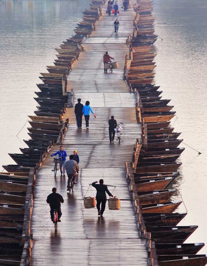
Wooden Boats Bridge, China:


A pontoon bridge or floating bridge or bridge of boats is a bridge that floats on water and in which barge- or boat-like pontoons support the bridge deck and its dynamic loads. While pontoon bridges are usually temporary structures, some are used for long periods of time. Permanent floating bridges are useful for sheltered water-crossings where it is not considered economically feasible to suspend a bridge from anchored piers. Such bridges can require a section that is elevated, or can be raised or removed, to allow ships to pass.Pontoon bridges are especially useful in wartime as river crossings. Such bridges are usually temporary, and are sometimes destroyed after crossing, or collapsed and carried. They were used to great advantage in many battles throughout time, including the Battle of Garigliano, the Battle of Oudenarde, and many others.Pontoon bridges have been in use since ancient times.In ancient China, the Zhou Dynasty Chinese text of the Shi Jing records that King Wen of Zhou was the first to create a pontoon bridge in the 11th century BC. However, the historian Joseph Needham has pointed out that in all likely scenarios, the temporary pontoon bridge was invented during the 9th or 8th century BC in China, as this part was perhaps a later addition to the book. Although earlier temporary pontoon bridges had been made in China, the first secure and permanent ones in China came first during the Qin Dynasty. The later Song Dynasty.Chinese statesman Cao Cheng once wrote of early pontoon bridges in China.

Source:
Picture:Link:
Wikipedeia:Link:
Read More 0 comments

Wednesday, 23 October 2013


Zhangjiajie, Hunan, China:


Zhangjiajie is a prefecture-level city in the northwestern part of Hunan province. It comprises the district of Yongding and counties of Cili and Sangzhi. Within it is located Wulingyuan Scenic Area which was designated a UNESCO World Heritage Site in 1992 as well as an AAAAA scenic area by the China National Tourism Administration.The city itself was previously named Dayong, and has a recorded history dating back to 221 BC. Humans lived here along both banks of the Lishui river, now within the boundaries of Zhanagjiajie City, very early during the Stone Age. Human settlement in this region dates back 100,000 years, rivaling such famous sites as Xi’an, Beijing and others. In 1986, the Academy of Chinese Social Science discovered Stone Age relics in Cili County, unearthing 108 articles of stoneware; mostly tapered-form, hacked-tamped and plate-shaped works. According to archaeological experts’ textual research, all of these wares were produced about 100,000 years ago. Shortly thereafter, in 1988, the Archaeological Institute of Hunan Province found other relics in Sangzhi County, including three pieces of stoneware which were estimated to have been fashioned over 100,000 years ago.Ten thousand years ago, those who lived within the boundaries of what is now Zhangjiajie City employed fire to bake pottery. Archaeologists have found more than 20 relics of this kind in Cili County, while in Sangzhi County, a black clay pot adorned with a unique design was unearthed dating back ten thousand years. During that period, this pottery-firing technique was the most advanced in China. These technological advancements in the fashioning of stone tools and pottery would seem to indicate a highly developed culture in this region. However, the society which developed only endured briefly before waning and being superseded by other regional powers. This seems understandable in view of Zhangjiajie's remote geographical position, its undeveloped land and river transportation, and its mountainous terrain making cultivation difficult. For these reasons, Zhangjiajie has been labeled "the Land of the Savage Southern Minority" since the earliest recorded history. Additional name descriptors have been the "Wuling Rude People" and "Tujia Rude People", indicative of discriminatory views held against the regional culture.The new name of Zhangjiajie City was adopted in 1994, after the National Forest Park in the Wulingyuan Scenic Area in order to give it more prominence and after this site had been designated a UNESCO World Heritage Site in 1992. The National Forest Park had been given the name of Zhangjiajie after the name of a small village located within its bounds, and now a popular tourist attraction within the park. The three-character name can be interpreted as follows: "Zhang"is a common surname in China; "jia" can be translated as "family"; and "jie" can be translated as "homeland", giving the completed translation of "Zhang family homeland." It has been reported that at least one tourist guide has said that the name may have been chosen to convey the idea or impression of "Open the family door to welcome the world" but this is not the locally-accepted and directly translated meaning of the name. The official version of its name is linked to a Han general, Zhang Liang, who resettled in the area after a suspicious Liu Bang, the Han emperor, started to persecute his staffs and generals who had contributed to his becoming emperor. It was so named to signify that the Zhang family had set up home there.

Source:
Picture:Link:
Wikipedeia:Link:

Read More 0 comments

Tuesday, 22 October 2013


Yunnan Stone Forest ,Yunnan, China:


The Stone Forest or Shilin is a notable set of limestone formations located in Shilin Yi Autonomous County, Yunnan Province, People's Republic of China, near Shilin approximately 120 km from the provincial capital Kunming. The tall rocks seem to emanate from the ground in the manner of stalagmites, with many looking like petrified trees thereby creating the illusion of a forest made of stone. Since 2007, two parts of the site, the Naigu Stone Forest and Suogeyi Village, have been UNESCO World Heritage Sites as part of the South China Karst.The site is classified as a AAAAA-class tourist site.According to legend, the forest is the birthplace of Ashima, a beautiful girl of the Yi people. After falling in love she was forbidden to marry her chosen suitor and instead turned into a stone in the forest that still bears her name.Each year on the 24th day of the sixth lunar month, many Yi people celebrate the Torch Festival, which features folk dances and wrestling competitions.

Source:
Picture:Link:
Wikipedeia:Link:
Read More 2 comments

Saturday, 19 October 2013


Red Beach in Panjin, China:


Panjin is a prefecture-level city and a major oil production centre of Liaoning province, People's Republic of China, and is situated on the northern coast of Liaodong Bay of the Bohai Gulf. It borders Anshan to the northeast and east, Yingkou across the Liao River, as well as Jinzhou to the west and northwest. The city has an administrative area of 4,071 square kilometres, in which 1.28 million people reside.Panjin is located between 40° 40'−41°27' N and 121° 31'−122° 28' E. It has a continental climate with four distinct seasons and some maritime influence, an annual mean temperature of 9.2 °C and receives over 2700 hours of sunshine a year. The city sits on the open field between the Liaodong Peninsula and the western portion of Liaoning Province. The Shuangtaizi River, which diverts from the Liao River upstream from the city, runs through the city and flows into the Liaodong Bay. The Liao River serves as the border between Panjin and the city of Yingkou. The two other prefecture-level cities that borders Panjin are Jinzhou and Anshan.Shuangtaihekou State Natural Reserve, a marshland that serves as natural habitat to 321 species of animals. It also serves as one of the few breeding grounds for endangered birds such as the red-crowned crane and Saunders' Gull. Millions of birds of as much as 172 different species stop at the area during their migration, including more than 20 endangered species such as the red-crowned crane, Demoiselle Crane, white stork, black stork, white-fronted goose, whooper swan, and brown goshawk. On a special note, Panjin is also called "Home of the Cranes" for the above reasons.reed-grass beach and the clam mound.Red Seabeach.Hubin Park in Panshan, featuring the Liaohe Tablets. These stone tablets bear inscriptions of Chinese calligraphy by historical and contemporary artists.The main industries in Panjin include oil, petroleum refinery, tourism, and agriculture, primarily rice. The short grain rice of Panjin are of high quality and great taste. Panjin is also famed for its Chinese mitten crabs, a famous delicacy in Chinese cuisine. They can be processed into crab meat tofu and "drunken crab".

Source:
Picture:Link:
Wikipedia:Link:

Read More 0 comments

Sunday, 13 October 2013


Fenghuang County is located in Xiangxi Prefecture, Hunan Province, People's Republic of China. It has an exceptionally well-preserved ancient town that harbors unique ethnic languages, customs, arts as well as many distinctive architectural remains of Ming and Qing styles. The town is placed in a mountain setting, incorporating the natural flow of water into city layout.  Over half of the city's population belong to the Miao or Tujia minorities. It was the center of the unsuccessful Miao Rebellion , which created a Miao diaspora in Southeast Asia during the last two centuries. The city is revered in Miao traditions and funeral rites and is the location of the Southern China Great Wall  pinyin: Zhōngguó Nánfāng Chángchéng; Miao: "Suav Tuam Choj", a fortification built by the Ming dynasty to protect the local Han Chinese from Miao attacks.The ancient town of Fenghuang was added to the UNESCO World Heritage Tentative List on March 28, 2008 in the Cultural category.This ancient town was regarded as the most beautiful town in China by New Zealand writer Rewi Alley. It was built in Kangxi forty-three years (1704), and has 300 years of history. The ancient city is a gathering place for Miao and Tujia ethnic. 
Source:
Picture:Link:
Wikipedia:Link:
Read More 0 comments